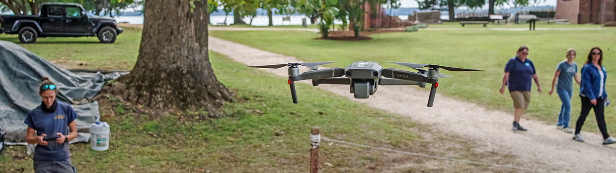
As colder weather rolls in several of the dig sites are being backfilled, preserving the archaeological resources now that their excavations are complete. Before the dirt was poured back in, the team used both drone and traditional photography to record and produce 3D models of the dig sites. But the winter won’t mean the end of field archaeology until the spring. The Jamestown Rediscovery archaeologists will begin work in the 1680s Church Tower in January, excavating the builder’s trench and looking for the 1607 palisade wall that should run right through it. As they determine where to open additional excavations when the spring arrives, they’ve been looking at archaeological findings from the 1940s that show interesting features close to the Pitch and Tar Swamp. Unfortunately these once-dry areas may be too saturated to excavate with the encroachment of the swamp since then. The conservation and curatorial teams were busy this month processing the human remains from last month’s burial excavations. Additionally they brought some horse furniture artifacts to be X-rayed at the Maryland Archaeological Conservation Lab and discussed their approach to their reference collection as we continue to work on ours. The Vault has had several researchers visit this month, including Bly Straube, our former Senior Curator, who is giving two presentations in Europe on Bartmann jugs.
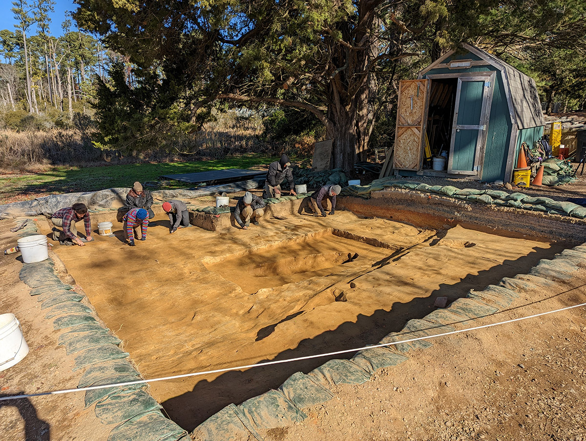
In an area to the north of the fort, close to the swamp, excavations are wrapping up on a series of squares begun due to the presence of what was thought to be a burial. National Park Service excavations in the 1940s indicated the presence of an unexcavated burial but in the words of Senior Staff Archaeologist Sean Romo, there was “nobody home.” Removing all layers down to the subsoil yielded no discernible presence of human remains in a feature that had the shape and size of a burial. The function of this feature is currently unknown. In an effort to get the bounds of the “burial” and compare the soil in its encompassing square with those adjacent to it, 5 10×10 squares were excavated in the area, and other archaeological features were discovered in the process. A pit or cellar was found in the southern part of these excavations. Ground-penetrating radar (GPR) scans of the feature indicate it’s about three feet deep but the construction date is unknown. The current thought is that it dates to the 1650s or later; brick found inside the feature gives evidence for this as large-scale brickmaking at Jamestown didn’t occur until the mid 17th century. Four postholes were also found in these excavations, one of which was cut by the cellar, indicating it was dug earlier than the cellar. The archaeologists are unsure if the postholes are part of a building, or a fence, or are even related to each other. Further excavations in adjacent squares will need to be conducted to connect the dots. The team is preparing to backfill these squares…they may come back to this area but attention is needed elsewhere on the site. Backfilling protects the archaeological features from damage caused by weather and people.
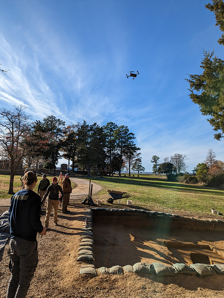
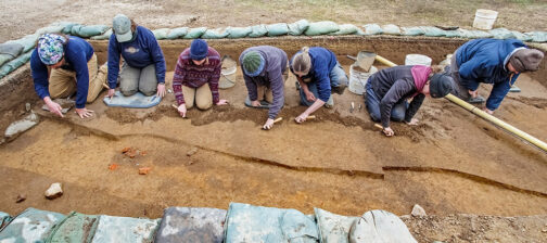
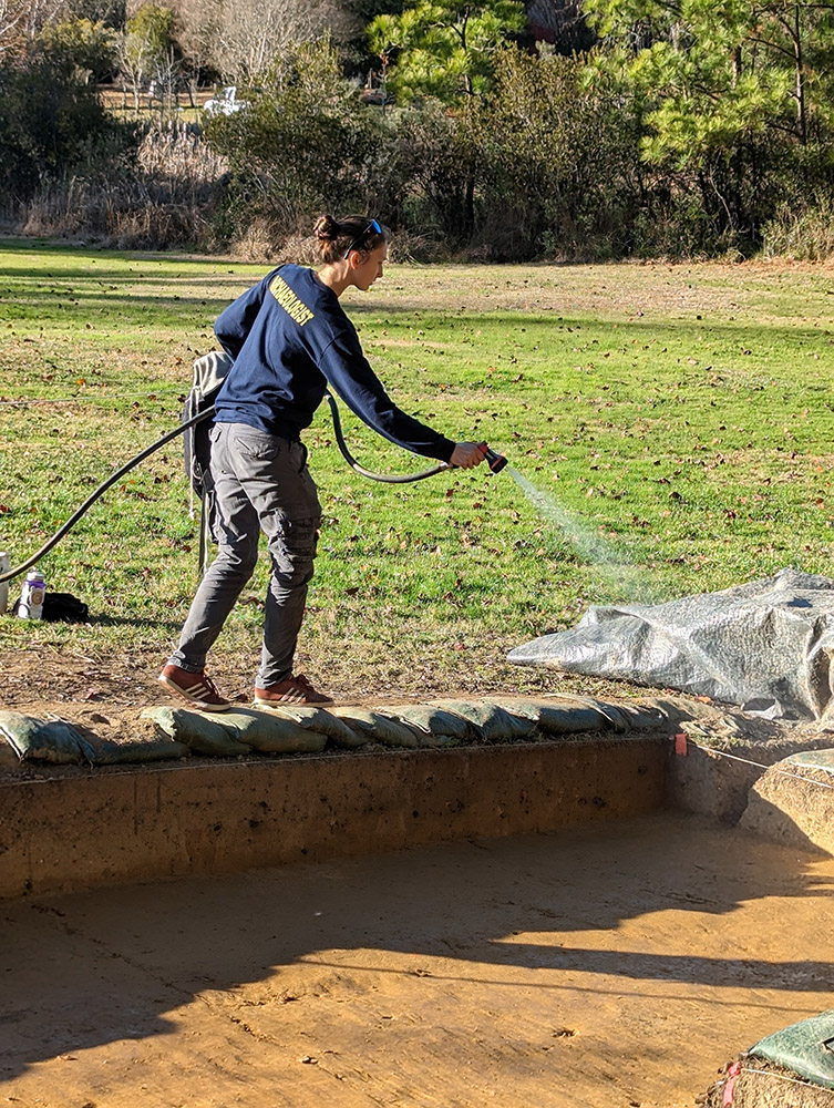
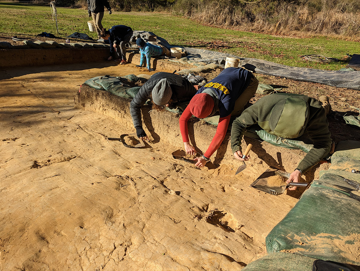
Before the backfilling begins, the team is meticulously cleaning the site to prepare it for photography from both the air and ground. Site Supervisor Anna Shackelford used a drone to take overviews of the feature, a process that used to require the use of very tall ladders or expensive construction lifts. She takes shots of the squares, both scored and unscored. “Scoring” — using a trowel to mark the boundaries of features and different soil layers — helps highlight these differences when referencing this part of the site for future research and planning. The team has also been placing ground control points (GCPs) at certain spots in the excavations in order to enable photogrammetry. Photogrammetry uses traditional photography to create 3D digital models of objects and features. Senior Staff Archaeologist and Staff Photographer Chuck Durfor uses his photographs and software expertise to create rotatable models of our archaeological features that are accurate to within a fraction of an inch. This allows almost “being there” analysis of our features that photography alone can’t provide. The software detects GCPs, colored in a highly-visible yellow or neon green, to skin the model with the photographs. Thanks to the surveying done by the archaeological team, the models also include latitude and longitude data. This area may be revisited for further excavations, including investigating the cellar, but the backfilling will preserve the site in the meantime.
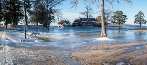
There is a renewed emphasis on digging near the expanding Pitch and Tar Swamp as it swallows more and more of the island. At NOAA’s Sewell’s Point station near the naval shipyard in Norfolk, the river has risen nearly a foot and a half since 1930. This is consistent with what we’ve seen on Jamestown Island where archaeological features excavated by archaeologists in the 1930s and 1940s are now underwater or so close to the swamp that excavations would be prohibitively difficult. One such area threatened by the swamp is close to the footbridge that takes visitors across it and onto dry land. Excavations in 1941 indicated the presence of a possible palisade there and our team is interested in taking a further look, but it may not be possible due to the saturated ground. If excavations are possible we may revisit this area next year.

The excavations to the west of the Church Tower have been backfilled and preparations are underway for doing the same north of the Tower. The same record photography and photogrammetry conducted at the “burial” site will also be performed here prior to the backfilling. The pit at the north Church Tower excavations that contained Virginia Indian ceramics and English brigandine armor was much shallower than expected. Big stones found in the area appear to be of the same type used as part of the foundations of the 1617 church. These may have been removed from that foundation and discarded when the later 1640s church was built on nearly the same spot and which foundation cut through the earlier church’s. With last month’s excavations at the 1607 burial ground complete, the excavation tent will be dismantled until next fall when it will be reassembled a few feet away and three additional graves excavated.
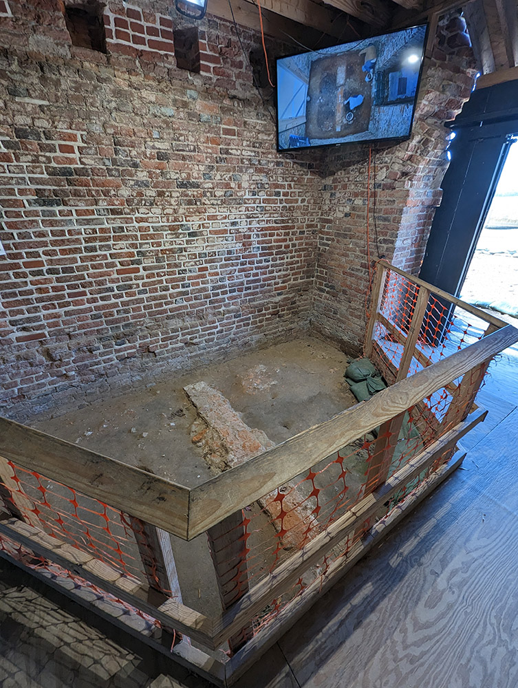
Preparations are being made to do excavations in the floor of the Church Tower. A glass roof is in the works for the Tower. It has been roofless for about 250 years, its interior subject to the ravages of the outdoors since then. The roof will not be visible from the outside and thus the iconic facade will be maintained. The interior bricks were never meant to be exposed to the elements. These lower-fired, less-expensive bricks are more subject to damage from moisture and freeze/thaw cycles. In preparation for the roof’s construction and a glass floor that will allow visitors to view the foundations and archaeological features beneath, excavations will be conducted this winter by our team. James Fort’s eastern palisade wall should run right through the Church Tower and possible evidence of the original timber frame tower’s demise during Bacon’s Rebellion can currently be seen in the form of blackened soil there. Additionally the present Church Tower’s builder’s trench will be excavated. Although we are almost certain the Tower was built in the 1680s it would be nice to find diagnostic artifacts in the trench that would corroborate that assumption.
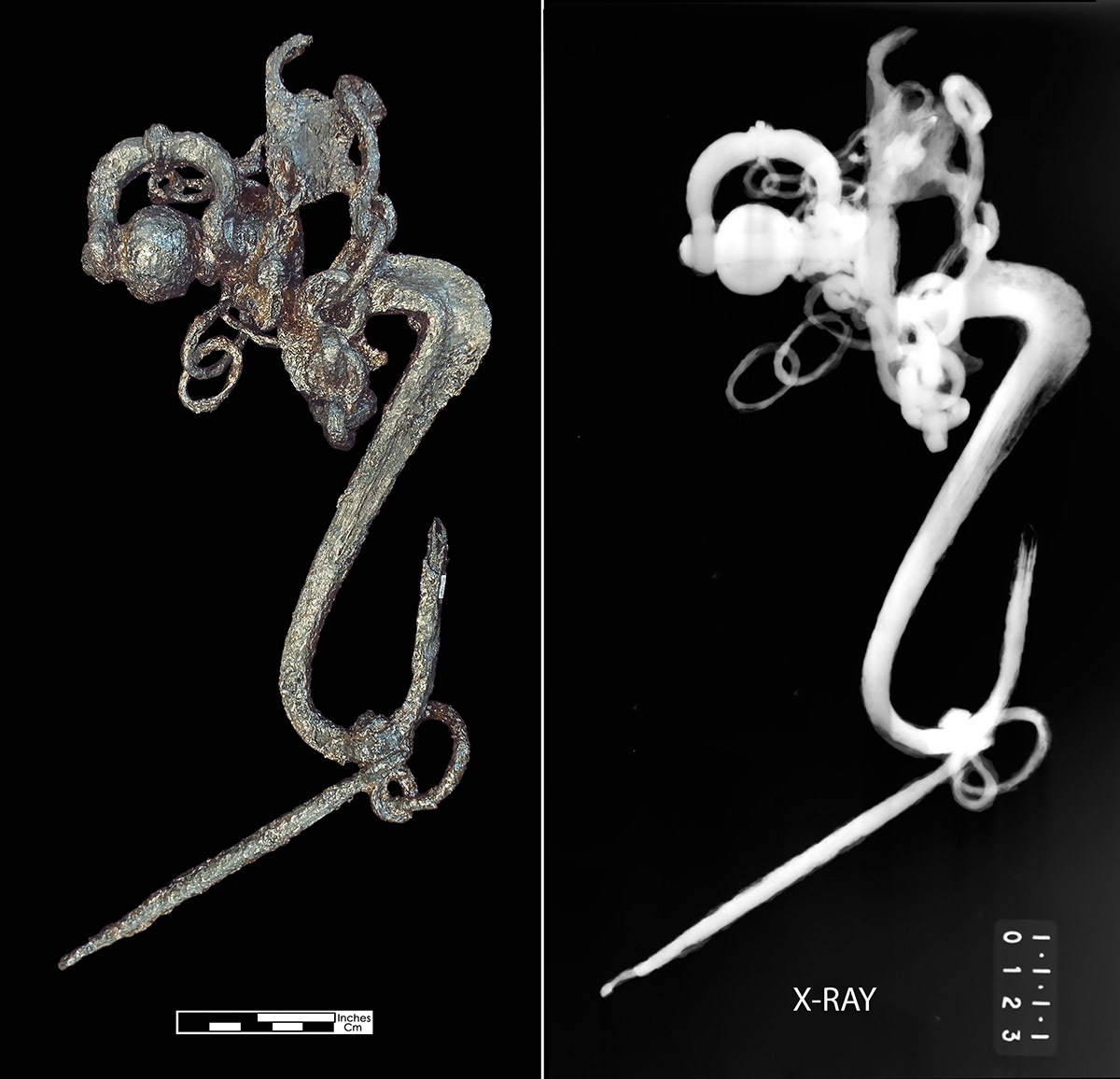
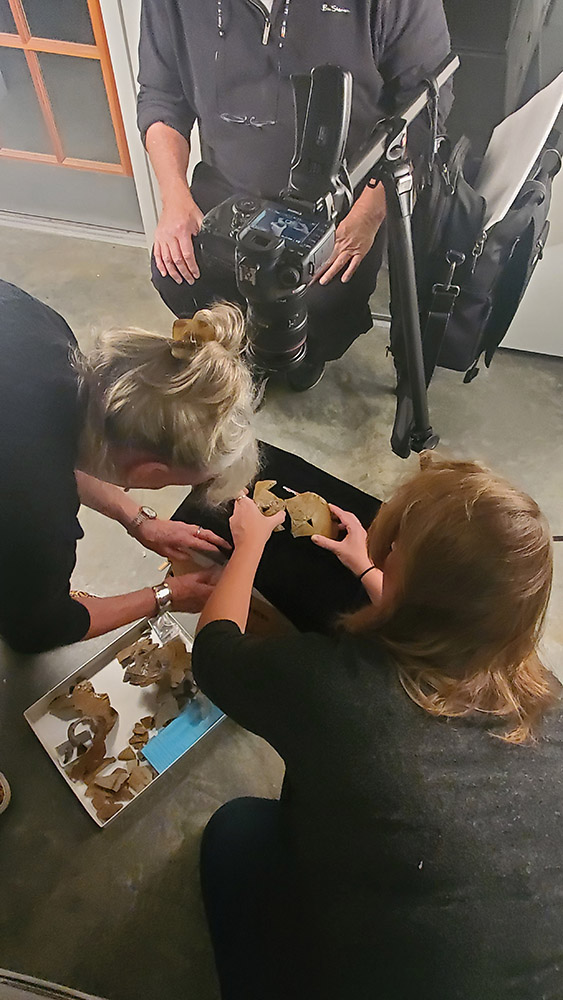
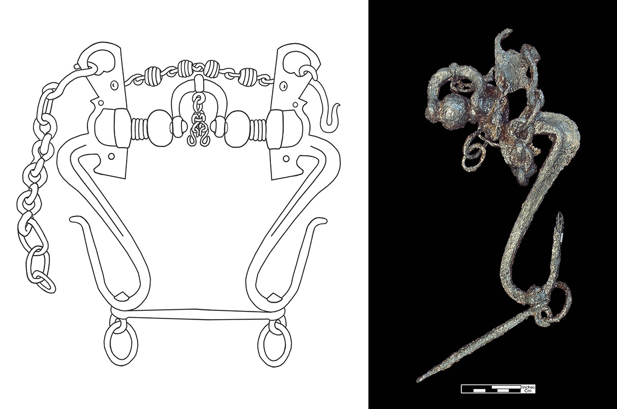
In the lab our conservation team has been busy this month examining and conserving the human remains from October’s burial excavations. This includes cleaning, mending, and cataloging the remains. Now begins the process of research…learning what these people can tell us about who they are, where they came from, and how they met their demise. Studying DNA is one way we learn about people buried at Jamestown. You can read more about this process in our blog post “Do You Think You Know Who You Are?” Several members of the curatorial and conservation team brought selections from the horse furniture in the Jamestown collection to be X-rayed at the Maryland Archaeological Conservation (MAC) Lab. One of these artifacts, a horse bit, is a complicated piece made confusing by rust concretions and the intricate nature of the bit itself. X-rays help differentiate between areas of rust and original metal that tends to be thicker. This is not always the case though…sometimes artifacts have very little to no original metal remaining. X-rays show this, helping conservators to first “do no harm” in their efforts to preserve artifacts. Sara Rivers-Cofield, an archaeological curator at the MAC Lab, has been studying horse furniture as part of research funded by the Skiffes Creek Curation and Conservation Research Plan. She is including the Jamestown horse furniture as part of her research and as Jamestown’s X-ray equipment is currently being replaced, our team brought the artifacts to be X-rayed there. Additionally the team discussed collections policies with the staff at the MAC Lab, with a focus on how they put their reference collection together, a relevant topic for our curators as they continue to build ours.
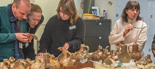
Our curatorial interns have completed picking through the tiny finds from the fort’s second well, looking for faunal remains to be analyzed by outside zooarchaeological consultants. Our work on the buttons collection and Portuguese ceramics continues. Bly Straube, former Senior Curator at Jamestown Rediscovery, is back in familiar environs in the Vault. She is examining and photographing selections from our Bartmann jug collection for a presentation she’s giving in Germany on Rhenish stoneware in December. Later in January she’ll be joining much of our staff in Lisbon, Portugal at the Society for Historical Archaeology conference to give a presentation there on the same topic. Researcher Judi Paulos was on-site this month, taking photographs of some of the projectile points found at Jamestown. She’s assisting Christopher Egghart from the Virginia Department of Environmental Quality on a guide he’s producing on Virginia Indian projectile points. Jamestown is one of the sites used for the guide which will help identify and show variation of projectile point designs across the state. The guide is scheduled for release next year.
related images
-
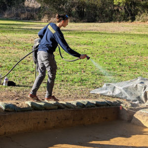
- Site Supervisor applies water to excavations to make the features stand out for the photographs.
-
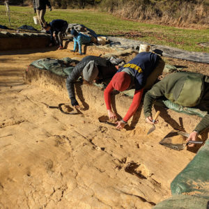
- The team painstakingly scrapes down to the feature layer prior to record photography.
-
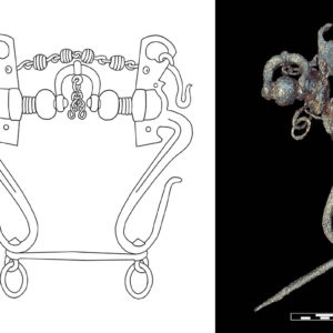
- Sara Rivers-Cofield’s conception of what a complete version of the horse bit would look like.
-
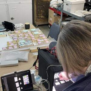
- Judi Paulos takes photographs of some of the Virginia Indian projectile points in the Jamestown collection for inclusion in Christopher Egghart’s guide on the subject.