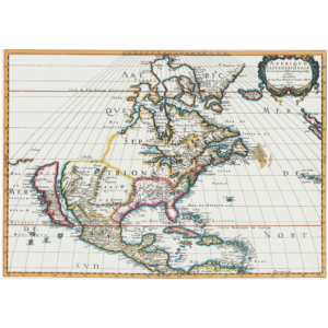
Description
Below the map reads: “On May 13, 1607, a small band of adventurous men stepped on shore at Jamestown, Virginia, to establish the first permanent English settlement in America. The map reproduced here constitutes a vital and exciting phase of their story. It is the most important map to appear in print during the period of early settlement. Until its appearance, there was no recognizable mapping of the Chesapeake Bay area.”
First published at Oxford, England 1612, and reproduced through the courtesy of The Virginia Historical Society, this detailed and remarkably accurate map helps us picture what Virginia looked like in the days of John Smith.
This reproduction is printed on antiqued parchment, and measures approximately 15 ¾” wide by 13 ¾” long (comes folded in a 9 ½” by 4 ¼” envelope).